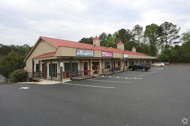
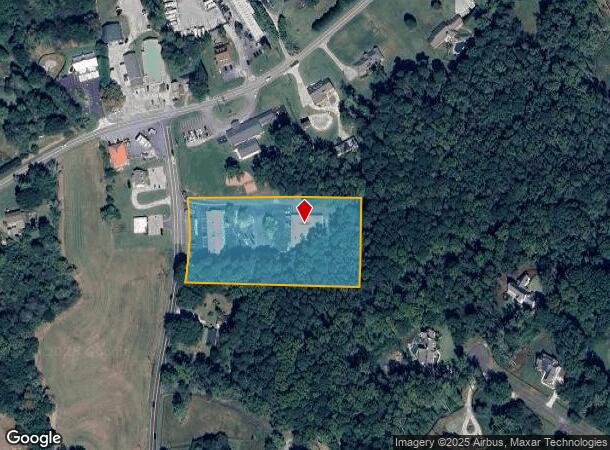
Property Record
5060 Sugar Pike Rd, Canton, GA 30115
NEARBY LISTINGS FOR SALE OR LEASE
Property Detail
5060 Sugar Pike Rd
Atlanta-Sandy Springs-Roswell, GA
Dmc Services Llc Surv
002N06-00000-019-000-0000
LL 136 2ND D
Regionalshoppingcenterormallwithanchorstore
Cherokee
X
Georgia
13057C0260E
136
2025
3.65 AC
2025
Cherokee/Woodstock
090809
Atlanta
17,310 SF
DEMOGRAPHICS near 5060 Sugar Pike Rd
1 Mile
3 Mile
5 Mile
2024 Total Population
1,285
14,871
51,847
2029 Population
1,463
16,940
58,559
Pop Growth 2024-2029
+ 13.85%
+ 13.91%
+ 12.95%
Average Age
42
41
41
2024 Total Households
438
4,992
17,232
HH Growth 2024-2029
+ 13.93%
+ 14.06%
+ 13.23%
Median Household Inc
$127,344
$129,708
$127,237
Avg Household Size
2.90
2.90
3.00
2024 Avg HH Vehicles
3.00
2.00
2.00
Median Home Value
$469,897
$461,518
$447,262
Median Year Built
2001
2003
2002
Nearby Places
- Restaurants
- Banks
- Shops
- Fitness
- Groceries
SALE & LEASE HISTORY
LISTING DATE
SALE/LEASE

Sep 25, 2016
For Lease
Feb 21, 2017
For Sale
Aug 09, 2018
For Lease
Nearby Properties
Address
Land Use
TOTAL SIZE
Lot Size
Zoning
Address
Land Use
TOTAL SIZE
Lot Size
Zoning
75,645 SF
16.76 AC
OI
Address
Land Use
TOTAL SIZE
Lot Size
Zoning
133,843 SF
31.69 AC
AG
Address
Land Use
TOTAL SIZE
Lot Size
Zoning
123,941 SF
18.41 AC
GC
Address
Land Use
TOTAL SIZE
Lot Size
Zoning
40 AC
AG1
Address
Land Use
TOTAL SIZE
Lot Size
Zoning
34.71 AC
AG1
Address
Land Use
TOTAL SIZE
Lot Size
Zoning
39.21 AC
AG1
Address
Land Use
TOTAL SIZE
Lot Size
Zoning
3,856 SF
46.80 AC
AG1
Address
Land Use
TOTAL SIZE
Lot Size
Zoning
1,024 SF
36.41 AC
AG1
Address
Land Use
TOTAL SIZE
Lot Size
Zoning
928 SF
37.43 AC
AG1
Address
Land Use
TOTAL SIZE
Lot Size
Zoning
60,882 SF
12.94 AC
GC
Address
Land Use
TOTAL SIZE
Lot Size
Zoning
25.89 AC
AG1
Address
Land Use
TOTAL SIZE
Lot Size
Zoning
2,138 SF
29.87 AC
AG1
Address
Land Use
TOTAL SIZE
Lot Size
Zoning
21.42 AC
AG1
Address
Land Use
TOTAL SIZE
Lot Size
Zoning
55,778 SF
5.28 AC
GC
Address
Land Use
TOTAL SIZE
Lot Size
Zoning
25.65 AC
AG1
Address
Land Use
TOTAL SIZE
Lot Size
Zoning
21.50 AC
AG1
Address
Land Use
TOTAL SIZE
Lot Size
Zoning
26.59 AC
AG1
Address
Land Use
TOTAL SIZE
Lot Size
Zoning
1,137 SF
15.99 AC
AG1
Address
Land Use
TOTAL SIZE
Lot Size
Zoning
20.65 AC
AG1
Address
Land Use
TOTAL SIZE
Lot Size
Zoning
24,158 SF
2.59 AC
NC
Address
Land Use
TOTAL SIZE
Lot Size
Zoning
14.50 AC
AG1
Address
Land Use
TOTAL SIZE
Lot Size
Zoning
19.55 AC
AG1
Address
Land Use
TOTAL SIZE
Lot Size
Zoning
14.21 AC
AG1
Address
Land Use
TOTAL SIZE
Lot Size
Zoning
13 AC
AG1
Address
Land Use
TOTAL SIZE
Lot Size
Zoning
44.72 AC
AG
Address
Land Use
TOTAL SIZE
Lot Size
Zoning
25,525 SF
2.62 AC
GC
Address
Land Use
TOTAL SIZE
Lot Size
Zoning
15.50 AC
AG1
Address
Land Use
TOTAL SIZE
Lot Size
Zoning
22,988 SF
5.41 AC
GC
Address
Land Use
TOTAL SIZE
Lot Size
Zoning
9.68 AC
AG1
Address
Land Use
TOTAL SIZE
Lot Size
Zoning
15,691 SF
2.52 AC
GC
The World's #1 Commercial Real Estate Marketplace
Connect with us
© 2025 CoStar Group
The information above has been obtained from sources believed reliable. While we do not doubt its accuracy we have not verified it and make no guarantee, warranty or representation about it. It is your responsibility to independently confirm its accuracy and completeness. Any projections, opinions, assumptions, or estimates used are for example only and do not represent the current or future performance of the property. The value of this transaction to you depends on tax and other factors which should be evaluated by your tax, financial, and legal advisors. You and your advisors should conduct a careful, independent investigation of the property to determine to your satisfaction the suitability of the property for your needs.